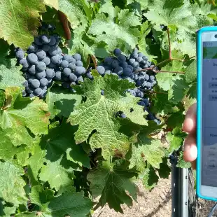
TomatoDSS is the solution for eating and industrial tomato that allows crop monitoring through vegetation indices from satellite and the creation of prescription maps.
Farmers are provided with specific forecast models on the plant development (phenology), on its water and nutritional needs and on the risk of diseases and harmful insects (defense), such as Tuta absoluta and tomato Downy mildew.
In this way, forecasting data can be integrated with those collected in the field to make targeted and effective decisions.
Why choose TomatoDSS:
- Increase yield and quality of tomato
- Reduce management cost
- Defend the crop against Tuta absoluta and Downy mildew
- Optimize the use of water
- Monitor crops health, even remotely
Features
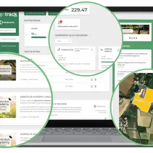
- FIELD MAPPING
Geolocate the field on the map and draw it: features will be immediately hooked. You can enable the cadastral map and enter sheet and parcel information. - SATELLITE IMAGERY
Consult Sentinel-2 satellite images of the field with vigor, water stress and chlorophyll indices to assess crop health and plan monitoring activities. - CROP OPERATIONS
Register where, how and when crop operations (transplanting, treatments, fertilization, harvest) have been carried out. You can also access phytosanitary products database. - PRODUCTION LOTS
Create and assign to each crop its own production lot to improve traceability of operations. A QR code is also generated that allows you to access and share the dedicated web page where you can consult all the information on the product. - PRESCRIPTION MAPS
Choose the most suitable vegetation index to draw up the prescription map and carry out a variable rate fertilization. - SUSTAINABILITY
Create and assign to each crop its own production lot to improve traceability of operations. A QR code is also generated that allows you to access and share the dedicated web page where you can consult all the information on the product. - PHENOLOGY FORECAST MODEL
Prediction of phenology to assess field needs in each development stage. - IRRIGATION FORECAST MODEL
Evaluation of water requirements to assess the onset of water stress. - FERTILIZATION FORECAST MODEL
Calculation of the total nitrogen, phosphorus and potassium needs (Kg/ha) required by barley and wheat in order to obtain suggestions on the doses of fertilizer to be applied. - PEST AND DISEASES FORECAST MODEL
Prediction of the risk of phytopathies (Tomato Downy mildew) and pests (Tuta absoluta and Helicoverpa armigera) in order to carry out an effective defense. - WEATHER FORECAST
Consult professional weather forecasts up to 7 days updated every hour: temperature, humidity, wind speed, rainfall. - CROP SCOUTING
Geolocate and register into the platform the field activities with Agricolus Farmer app: pest and diseases, crop damage, phenology, traps and catches. - TASK MANAGEMENT
Create and assign tasks to be done in the farms to your collaborator in real time. - WEATHER STATIONS
Virtual weather station included; physical weather stations and sensors can be purchased or integrated, if already present in the company. - DECISION SUPPORT
Suggest operations to be carried out based on collected data. - MACHINERY
Register your agricultural machinery, any problems and maintenance carried out. You can also connect them to Agricolus by using Agrirouter.
Gallery

Reviews
Sign-in to leave a review for the solution.
0.0/5
0 Reviews
Questions
Sign-in to leave ask a question about the solution.