Heavy equipment traffic, resting machinery, and water flow across seasons can cause compaction in fields. Even moderate compaction can inhibit the root growth of corn and soybeans. Deep tillage loosens the soil, but it's a costly and time-consuming process.
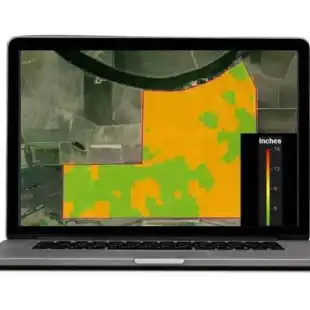
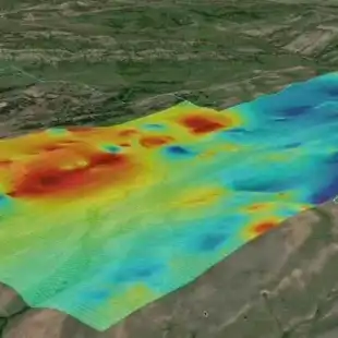
The EarthOptics TillMapper™ technology solves the problem. This precision soil mapping system and methodology precisely identifies the areas and depths where each individual field is compacted and quantifies the extent of the compaction. Using this data, growers are provided with a customized tillage prescription that can be adjusted to their preferences, including compaction threshold, max tillage depth and specific crop.
The output can be exported as either a multi-depth prescription or a binary till/no-till prescription, in any number of standard file types. As a result, growers can confidently till only where needed and to quantified levels.
- Compaction costs $20B annual lost yield in the US
- Gain improved soil structure and health while increasing carbon sequestration
- US farmers could save $1.5 billion in unnecessary expenses
Save time, fuel, carbon, and increase yield
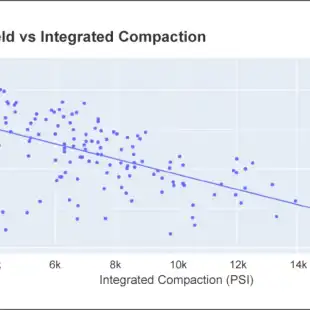
- 9.6 bushels of corn are lost ($52.89) for every 1,000 psi increase in the EarthOptics Integrated Compaction Score
- 1-3 gallons of diesel savings per acre not tilled
- Conserving carbon while reducing greenhouse gas emissions from diesel
TillMapper™: Automated Variable Depth Success
Till only where needed, with confidence.
- 100% Compaction eliminated
- 40% Cost savings over traditional tillage
- $15 Average cost savings per acre
Gallery